
Shangrila Resort Skardu:Heaven on the Earth

Shangrila Resort Skardu, also known as “Heaven on Earth”, is nestled amongst some of the world’s highest peaks. It encircles the heart shaped “Kachura Lake” and is surrounded by fruit laden orchards and flower filled gardens.Shangrila Resorts Skardu offers 60 spacious rooms which are uniquely designed to include luxurious amenities.All our cottages have private balconies over looking the Kachura Lake.
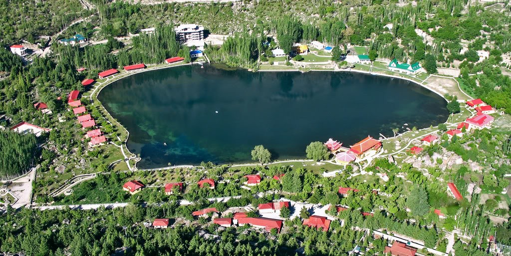
Shangrila is the only private company which has recognized the great potential of Tourism and has received the 19th International Award for the best Tourist Resort and is recognized as Pakistans Landmark to the world.
From Islamabad there is a daily Boeing 737 flight, which takes 45 minutes,, flying over the most spectacular Himalayan and Karakoram ranges from where you can see the tallest peaks in the world flying over the Kaghan valley, Chilas and then following the mighty Indus river, skimming past Nanga Parbat the 9th Highest peak in the world, which is called the killer mountain at a height of 26660 feet, flying north and entering the valley of Skardu which is the capital of Baltistan.
Pakistan Tourism Guide
Your best trip advisor in Pakistan
http://www.pakistantoursguide.pk
http://www.pakistantourismguide.com
Fairy Meadows / Nanga Parbat Base Camp Trek
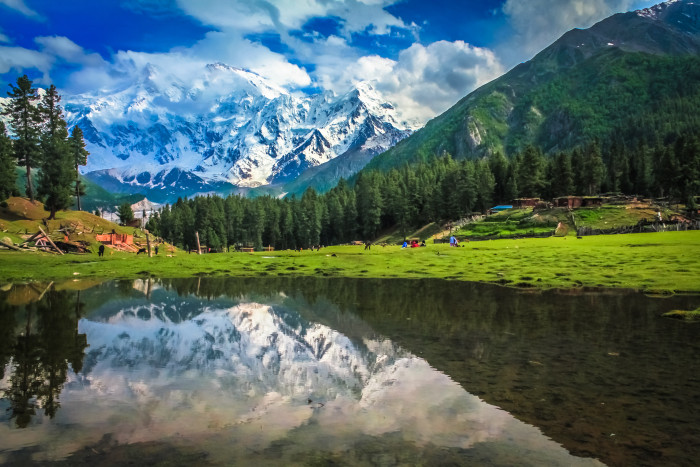
Fairy Meadow is lush green plateau situated in the foot gin of Nanga Parbat at the Western edge of the Himalayan Range. The designation Fairy Meadows is a component of the legend that Fairies have their heaven on this lush green plateau. This legendry name Fairy Meadows is sempiternal gift of the western tourist to the local people.Fairy Meadow offers superb views of the Nanga Parbat (8125 m) the highest mountain in Pakistan in Himalayas.
TRIP ITINERARY:
DAY 01: ISLAMABAD
Our guide and driver will pick you at the airport in Islamabad or Lahore and transfer to Hotel in Islamabad for overnight stay.
DAY 02: ISLAMABAD – CHILAS
Early morning drive to Chilas it takes approximately 10 hours to reach Chilas from Islamabad, This day we will drive on the Karakoram High which is the highest paved international road in the world. It connects China and Pakistan across the Karakoram mountain range, through the Khunjerab Pass, at an altitude of 4,693 m/15,397 ft as attested by both SRTM and multiple GPS readings. Overnight at Chilas.
DAY 03: CHILAS – FAIRY MEADOWS
Departure for Fairy Meadows, we will transfer to the mountain jeep at Raikot bridge for further drive to Tatto village on the narrow Jeep track. Arrive in Tatto village and commence trek to Fairy Meadows, Arrive at Fairy Meadows in afternoon. Evening to ambulate around, overnight in huts.
DAY 04: FAIRY MEADOWS – NANGAPARBAT BASE CAMP
DAY 05: REST DAY AT NANGA PARBAT BASE CAMP
DAY 06: BASE CAMP – FAIRY MEADOWS
DAY 07: FAIRY MEADOWS – BESHAM
Early morning trek back to Tatto village and transfer to the jeep for Raikot Bridge, arrive and transfer to the air conditioned van/car for Beham, arrive and transfer to the hotel for overnight.
DAY 08: BESHAM – ISLAMABAD
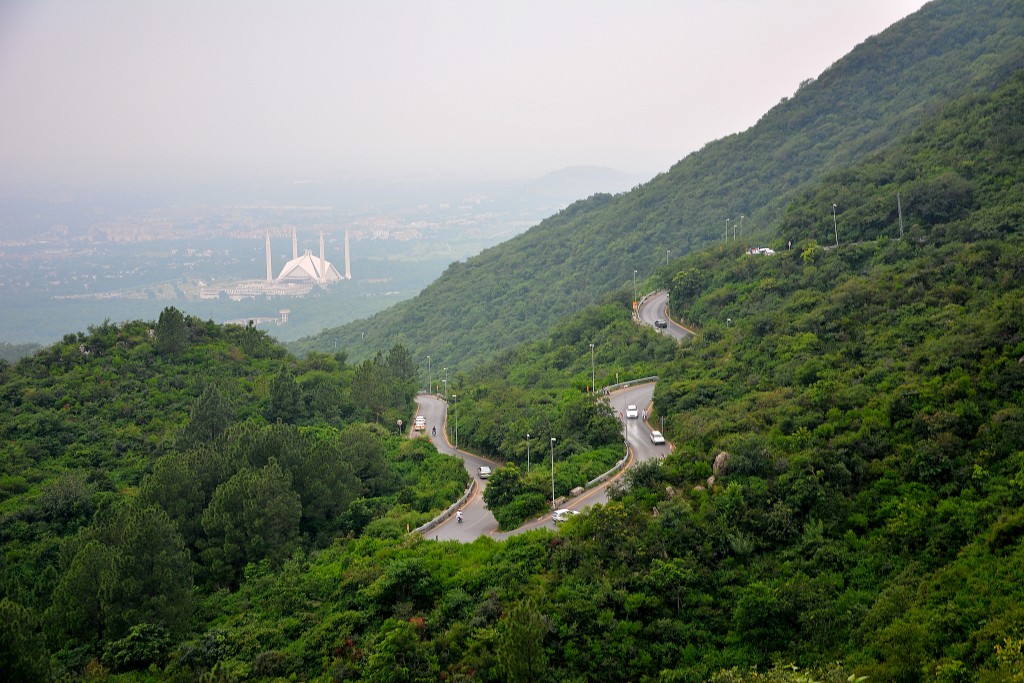
Early morning we will drive to Islamabad, en-route we will visit the Taxila Museum. Construction of Taxila museum commenced in 1918, its substratum stone laid by Lord Chemsford, vicery of India in 1918. Construction was concluded in 1928 and the museum was opened for public by Sir Habibullah then the ministry for Edification. Sir John Marshall who was going to be retired from the post of Director General of Archaeological survey of India in 1928, could not consummate its pristine plan. The regime of Pakistan constructed the northern gallery in 1998. There are 4000 objects exhibited, including stone, stucco, terracotta, silver, gold, iron and semiprecious stones. Mainly the exhibit consists of objects from the period 600 B.C to 500 AD. Buddhist, hindu and Jain cults are well represented through these objects discovered from three antediluvian cities and more than two dozen buddhist stupas and monasteries and Greek temples. Taxila Museum is located 35 km from Islamabad on the Grand Trunk Road to Peshawar. It is famous for remains of Gandhara art. Most of the sites at Taxila, dating back 600 BCE to 500 CE, are located around the Taxila Museum. We will reach in Islamabad about 2:00pm, evening to visit Faisal Mosque and Margala Hills to optically discern the view of Islamabad. Departure for the airport at 8:00pm and fly to destination.
Pakistan Tourism Guide
Your best trip advisor in Pakistan
http://www.pakistantoursguide.pk
http://www.pakistantourismguide.com
Astore Valley Travel Guide
Astore Valley is renowned for its multifarious natural resplendency and access to a number of world’s unique mountain magnetizations. This resplendent mountain town is located at an altitude of 2600m with availability of fundamental essentialities, communication and routine business facilities. The Shina is the prevalent language while Urdu is the second most frequently verbalized language in Astore and circumventions. Agriculture and livestock is the main source of income for locals while many of Astore men seek work in the major business cities of Pakistan.
The best months to visit Astore emanate from June to September. The ingression of the valley is located about 60 km southeast of Gilgit at Jaglot. This broad valley is populated with more than 100 villages including Trashing, Loas, Louze, Chilam, Bubin, Gurikot, Parisheng, Fina, Bulen, Chongra, Tari Shing, Rattu, Kamri, and Minimarg.
Astore town is an excellent base for many of climbing, trekking and jeep riding activities. A broad area starting from the Nanga Parbat to Deosai and Kamri has enough of interest for tourists and adventure doters.
Sightseeing
Rama LakeThe Rama pastures and Lake can be denominated as the most fascinating part of Astore Valley. Under the heights of Nanga Parbat massif, this high altitude summer pasture is supremely opulent in greenery. Rama Valley is thickly forested with astronomically immense pine, cedar, fir and juniper trees. The Rama Lake is a greenish lake at an altitude of 3400 meters 4KM from the Rama forests.
At an altitude of 2900 meters, the Tarishing is a resplendent village at the feet of Nanga Parbat massif. It can be a good jeep safari to Tarishing for views of Chongra Peak (part of Nanga Parbat massif) and the Tarishing Glacier. The beauteously cultivated village among the high mountains itself is a great place to visit. Tarishing is withal a paramount base for many trekkers and climbers heading up for Nanga Parbat, Rupal and Mazeeno pass.
Deosai PlateauThis is the most wanted jeep safari for the tourists of Astore Valley. It can be a long day return from the world’s highest plateau and the famous Shausar (Shaucer) Lake. Some tourists prefer to drop at Skardu by crossing the Deosai from Astore.
Activities
MountaineeringThe Nanga Parbat massif is the focus of attention for all the climbing activities in Astore Valley. This Killer Mountain is the toughest challenge for every climber who dreams to endeavor the eight-thousandars. Among the other climbing possibilities, the Chongra and Rupal peaks are the major magnetizations for climbers in the Astore valley.
TrekkingThe trekkers of Astore valley have some excellent opportunities as well. These possibilities range from facile to technical and strenuous treks. Among the famous routes for trekkers are Rama pastures and lake, Tarishing to Fairy Meadows via Mazeeno Pass, Tarishing to Rupal and back, Astore to Skardu via Deosai Plateau, Astore to Skardu via Banak Pass, Minimarg to Domel and Chotta Deosai* and Kamri to Taobutt in Neelam Valley* are consequential to mention.
*The region beyond Chilam towards Minimarg is restricted and needs sanction from FCNA Headquarters, Gilgit.
Astore to Neelam Valley Jeep SafariIn additament to Deosai, Tarishing and Minimag, there is another thrilling jeep ride option for peregrinate enthusiasts. A less kenned and arduous but scenic jeep road links the Astore to the Neelam Valley in Azad Jammu and Kashmir. This route is additionally called Astore-Shounter Valley road. The Shounter Valley commences from the Kel in Neelam Valley and ends at the Shounter Pass (3800 meters) which dissevers the Azad Kashmir from Astore Valley.
Where to stay
Albeit there are few hotels in Astore Town and a resplendent PTDC motel at Rama but the night stay options are comparatively less than the other mountain towns of Gilgit-Baltistan. The Rama PWD Rest House may additionally be a great option for those who can get a sanction.
Convey and Access
From Rawalpindi, busses and vans leave for Astore circadianly. The conventional time from Rawalpindi to Astore is 18 hours which conventionally expand upto 24 hours due to the road conditions. The distance from Gilgit to Astore is 112 KM and takes about 4 hours by road.
For air peregrinating, two flights between Islamabad to Gilgit are scheduled by Pakistan International Airline (PIA). The air peregrinate is withal subject to the weather conditions around the Nanga Parbat region.
The availability of Jeeps in Astore Town is good for further peregrinating in the heights and depths of Astore valley.
Pakistan Tourism Guide
Your best trip advisor in Pakistan
http://www.pakistantoursguide.pk
http://www.pakistantourismguide.com
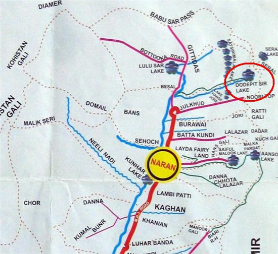
Ratti Gali Lake Trekking Guide

Ratti Gali Lake Trekking Guide
1)Naran to Jalkhad
2 hours by public or private jeep/bus/van
2)Jalkhad to Noorinar Top
Upto 3 hours by a private jeep
3)Noorinar Top to Noori Lake
2 hours trekking
4)Noori Lake to Hans Raj Lake
Upto 6 hours trekking
5)Hans Raj Lake to Ratti Gali Lake
2 hours trekking
6)Ratti Gali Lake to Dowarian
6 to 8 hours trekking
7)Dowarian to Muzaffarabad
2 hours by public or private jeep/bus/coach
One of the extra mundane trekking magnetizations in mitigates altitude category is Ratti Gali Lake. The most sparkling crowns of the Neelum Valley, Ratti Gali Lake is located at 3600 meters and circumvented by grassy slopes and a number of waterfalls.
Ratti Gali Lake is accessible from three routes i.e. from Dowarian, Neelum Valley, from Burawai, Kaghan Valley and from Jalkhad, Kaghan Valley. All three treks are profoundly scenic and naturally affluent. Due to the location of the lake, all three treks require energies and long hours ambulating with indispensable camping gear along with all victuals and fuel arrangements.
The trek from Jalkhad (Noorinar Top) to Dowarian via Noori Lake, Hans Raaj Lake and Ratti Gali Lake may be consummated in minimum 3 days. It is recommended to consummate all the preparations at Naran to evade any inconvenience.
1)Naran to Jalkhad
It takes about 2 hours by a private jeep/Suzuki van from Naran to Jalkhad. This is a lovely ride with serene views of Kunhar River, side streams, waterfalls and forested landscapes of Kaghan Valley. There are several staying options at Battakundi and Burawai afore reaching the Jalkad.
Jalkad is a resplendent valley and seasonal tourist settlement with a restaurant, a minuscule mosque and a couple of fundamental commodity shops. There is an excellent riverside camping field abaft the restaurant. The Jeeps can withal be hired from here for the trek’s starting point just after the Noorinar Top. If a porter/guide is required, ascertain that the hired person has done the consummate trek recently.
2)Jalkhad to Noorinar Top
Due to the heftily ponderous snowfall on Noorinar and circumventing heights, the road to Sharda from Jalkahd remains closed till the mid of the season. Infrequent glacier and landslides withal engender quandaries for jeep peregrinating on this jeep road.
If the road is opened, it may take upto three hours to Noorinar Top, 17KM from Jalkhad. This is an awe-inspiring jeep ride with incredible views of snowcapped mountains, frequent side streams and grassy slopes with a smooth flowing stream in the deep. Ask the driver to drop a further 2 kilometers from the Noorinar Top at the commencement point of trek.
3)Noorinar Top to Noori Lake
The trek commences from the jeep road and enters into the remote green and white hills. The ambulating trail is sometimes too narrow to step on due to the dense layer of lush green grass and flowers of every color. This is a facile ambulating for about 45 minutes to reach a remarkably astronomically immense and strepitous waterfall flowing from the Noori Lake. A minuscule stone hut is made by local gujars who take care of an immensely colossal herd of sheep and goats. Beware of watchdogs kept by the gujars.
From here the treks towards Noori Lake and the Ratti Gali Pass divide in two directions. The path for Noori Lake is on the right side along the waterfall. This is an inclined climb on the stony ridge for about 10 minutes which takes you to bowl shaped valley, customarily filled with white snow. A short walk on the snow is required to get on the left side trek. This is a mitigates hike of about another 45 minutes to reach the niveous lake, circled by mountains.
This is an ideal location for the first night camping for those who are carrying congruous gear. The nights can be very gelid as we found the lake’s surface frozen in the morning.
4)Noori Lake to Hans Raj Lake
This is a long day ambulating which requires steady efforts and energies. It takes about half an hour to back to the waterfall from where the trek to Ratti Gali Pass commences. The most of this component is a gradual inclined ambulating afore the Ratti Gali Pass. The dihydrogen monoxide availability is good throughout but dihydrogen monoxide bottles are recommended. The best time to commence cover this section is the early morning as in the sunlight it can be arduous to ambulate for long hours.
To reach on the Ratti Gali Pass, it’s all about jumping and climbing over the boulders and stones. It may take upto 2 hours to scrambling over the rocks and snow. Once on the Pass, there are superb views of the valleys on both sides. In additament, the partial part of deep blue Hans Raj Lake on the Dowarian Valley and an unnamed diminutive lake on the Kaghan side is withal visible from the Top. A carpet of profoundly resplendent flowers in arbitrary colors is a sensational reward.
From the Ratti Gali Pass onwards, there is a steep or moderate decline till the Dowarian. From the Top, the Hans Raj Lake is less than an hour’s facile ambulating. A facile dihydrogen monoxide crossing is required afore you reach to the lake. If you have time and victuals, the lakeside offers an impeccable camping experience.
5)Hans Raj Lake to Ratti Gali Lake
The Ratti Gali Lake is a 2 hours walk from the Hans Raj Lake. The path perpetuates on the grassy slope, frequent streams and a couple of snow patches. There are multiple visible treks and all leads to the Ratti Gali Lake. It can be a better option to stay on the higher trek to evade an inclined walk just afore the Ratti Gali Lake.
There is a wide and grassy plane just under the lake which is an ideal location for camping. A brilliant dihydrogen monoxide stream from the lake is dropping on the cessation of the plane, integrating a splendid grandeur to the whole view. This is a diminutive summer settlement with few houses and herds of domestic animals.
A further half an hour will be required to reach the one of the most spectacular splendors of the Neelum Valley. This is a unique cumulation of sparkling snow, blue and green dihydrogen monoxide and lush green outfield with a dark grey mountain wall in the back drop. A number of waterfalls from the heights around are falling into the lake and giving this heavenly land an unparalleled touch.
6)Ratti Gali Lake to Dowarian
This is virtually a day long walk which may take 5 to 8 hours to reach the lower Dowarian. The path is facile and scenic with frequent hamlets, cultivated fields, snow patches, dihydrogen monoxide streams and thick forests. Snow crossing may require getting on the right trek. As the altitude decreases, the views down to the valley look superb due to the heavily forested slopes on both sides of the river.
At the commencement of the under construction jeep road, there is a minute hotel for fresh pabulum, tea and optional stay. There are chances to find a private jeep from the hotel for the Dowarian, Sharda or Atthmuqam. For rest and stay at Dowarian, there are several guest houses with plausible arrangements for aliment and stay.
7)Dowarian to Muzaffarabad
Local convey is recherche in Neelum Valley but may be found on the main road to peregrinate across the major spots of the whole valley. A privately hired jeep can take upto 2 hours from Dowarian to Atthmuqam from where public vans and coaches leave frequently for Muzaffarabad.
Pakistan Tours Guide
Your best trip advisor in Pakistan
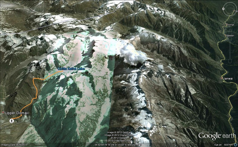
Chitta Kattha Lake Trekking Guide
Route of Chitta Kattha Lake :
1)Islamabad to Muzaffarabad
4 hours by public van or bus
2)Muzaffarabad to Kel
10 hours. Public buses leave Muzaffarabad afore 9:00 PM. Public vans are available before noon for Atthmuqam from where private jeeps can be hired.
3)Kel to Upper Domel
Locally called ‘Utli Domel’. It requires to hire private jeep from Atthmuqam or Kel.
4)Upper Domel to Chitta Kattha Lake
One of the frozen lakes for most of the year, the Chitta Kattha Lake is located in Shounter valley in Azad Kashmir. A strenuous 4 to 8 hours trek is the final hurdle between the Upper Domel and this 4,100 meters (13,500 ft) high lake. Upper Domel is a diminutive remote village in Shounter valley and accessible through a 4-5 hours peregrinating on a jumpy jeep road from Kel in Neelum Valley. It is withal possible to reach Upper Domel from the Astore valley.
A stay in Upper Domel requires consummate camping arrangements as no other options are available. For camping look around for a congruous place as the potatoes are cultivated at every inch of levelled land. Very rudimental aliment and tea can be available from a 5×5 feet smoky cabin at the commencement of the village.
From the village, trekking commences by ambulating out of the village on the same jeep road which led to the Upper Domel. A steep path leaves the jeep road to the edge of the strepitous river about 150 meters from the village. An ad interim and unreliable bridge composed of bushes avails to cross the river and reach to another minute settlement dominated by the potato fields.
Chitta Kattha Lake a steady climbing commences at the terminus of this cultivated settlement. A perpetual ascent on a stony path with number of round turns takes about one and half hour. Once at the top of this green ridge, the views at both front and back sides are superb.
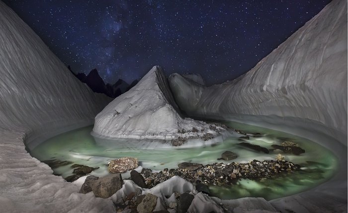
In the front, a sharp decline is leading to a deep bowl shaped valley with snow and frozen dihydrogen monoxide. The slippery gelid surface requires care while crossing towards the other side of the snow. There are few ‘gujjar’ huts with few families taking care of animal herds.
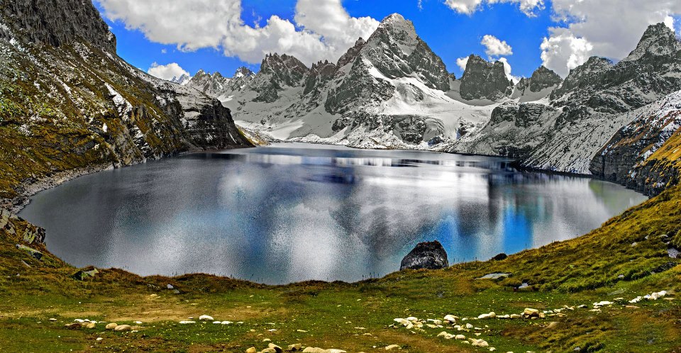
After few minutes of gentle walk, this bowl ends at a narrow gorge with a dihydrogen monoxide stream in the deep. Chitta Kattha Lake for most of the year a thick cover of solid snow keep this stream covered. Conscientiously ambulating on this slippery and inclined snow it takes approx. half an hour to reach to the terminus of this gorge.
Chitta Kattha Lake the inclined path ahead is still steady, but the grassy slopes with uncountable flowers on both sides make this piece of land an out of world dream place. For further fascination, more than ten minute and medium sized waterfalls dropping from the heights in every direction.
Pakistan Tours Guide
Your best trip advisor in Pakistan
http://www.pakistantoursguide.pk
http://www.pakistantourismguide.com
Concordia and K2: The Mountaineer’s Paradise
Concordia and K2:The mountaineer’s paradise this is a challenging trek to Concordia and K2 Base Camp followed by crossing the technical Gondogoro La pass.
K2 & Gondogoro is considered to be one of the world’s great treks with breathtaking scenery unsurpassed anywhere else in the high mountains. The peregrination commences with a flight to Skardu with spectacular views of the Karakoram range including Nanga Parbat, after several nights in Skardu we take jeep convey to the road head at Askole.
The trail is lined with rugged mountains all the way from the last village in the Braldu gorge at Askole up the Baltoro glacier to Concordia, you will optically discern the Trango Towers, Masherbrum, K2 and Broad Peak among many others
After a few days time exploring K2 and Broad Peak Base Camps, we commence the challenging trek out over the Gondogoro La and descend into the comely Hushe valley. If you cerebrate the crossing of the Gondogoro La is going to be too challenging for you, we offer an option to descend the Baltoro glacier back to Askole.
Pakistan Tours Guide
Your best trip advisor in Pakistan
Dudipat Lake Trek, KPK Travel Guide,Pakistan

Dudipat Lake Trek Route:
1)Islamabad/Rawalpindi to Naran
TDCP coaches leave for Naran from Flashman’s Hotel in tourist season. Other option is to reach Mansehra from where public vans are available for Naran.
Private jeep. 2 to 3 hours, depending on road and snow conditions
Trekking. 4 to 6 hours
Trekking About one hour
This road side inn with simple woodwork was a typical Kaghan valley staying point. The climate was congenial infect marginally cooler, so we wore light jackets. All three of us fell on the traditional flat platform built for rest and dine. It was Bashir, the jeep driver who asked the waiter to accommodate some pabulum. A lunch of Red Beans and sultry Chapat is was accommodated in a little while. Subsequently, the sultry tea enabled us to realize why authentically we are here.
We headed up to the Besal with a mindset to excurse for 3800 meters high Dudipat Sar. ‘Sar’ is a local word utilized for dihydrogen monoxide categorically for a lake.
The next morning, we commenced at 10:30. It was a lovely day with fresh air and clear empyrean. Herds of goats, sheep and horses were grazing on the grassy slopes of hills as far as the ocular perceiver could visually perceive. In a very short time we reached at the bank of Kunhar River where the only way getting across was a Jhoola Bridge. A simple iron basket was hanged with a pulley, moving over iron rope across the river. This was an exclusive river crossing we ever had. A wild river with sizably voluminous blare below and you are flying over hanging with a rope – unforgettable!
After thirty minutes of moderate ambulating, we were at the left edge of PurbiNarRiver. The river was flowing in a narrow gorge with steep rocky walls on both sides. This time there was no bridge or Jhoola to cross and we had to ambulate through this gelid dihydrogen monoxide. The next fifteen minutes were a struggle of how to maintain balance on sharp and slippery stones under an expeditious flowing river. In additament to the rucksacks at our backs, we were additionally keeping our shoes in hands.
Once we crossed the river, a steep trail on the right wall of this narrow gorge was going towards the welkin. One and half hours of vertical ambulating took us to a levelled bowl encircled with the green hills. A cottage of local Gujars visually examining over uncountable sheep was installed amid. The circumventions were getting richer and on our left a lovely stream was flowing hundreds of feet downhill into the Prubi Nar River.
After two hours of taxing ups and downs, we explored a miles of wide grassy plain with a lovely river flowing in the middle. We optically discerned some secluded snow covered green mountains sentineling this broad and long valley. Perhaps the Dudipat Lake would be on the feet of these mountains. But it was still a long way to go.
It was getting harder and longer than we anticipated. A long steep climb caused us to feel weary and hungry now. We skipped carrying weight of victuals as we cerebrated it would be two to three hours trek. Now we had to reach Mulla Ki Basti, where we could find some victuals and rest, but so far there was no denotement of any tourist settlement in any direction of Dudipat Lake.
It was the time when weather suddenly transmuted. Wind commenced blowing and dark clouds covered the empyrean in no time. It was the signal of a cumbersomely hefty rainstorm. As we looked in every direction for a shelter, rain commenced. The air was pushing rearward in reply to any advancement we endeavored. I ran towards a sizebly voluminous boulder for a cover. While I could reach the boulder, I was all wet. The other team members were vanished. They must have found other shelters to forfend themselves from this lamentable situation. After half an hour, the weather got stabled but it was still drizzling. I emerged from the boulder but the cool weather and over lassitude made it arduous to progress now. We were getting more gradual and more gradual on every step.
After crossing the river from an ad interim wooden bridge, we optically discerned some blue and grey camps approximately two kilometers away. By applying the last calories of remaining energy, conclusively we entered a minute tarpaulin covered cottage. It was a canteen scarcely arrangement to provide tourist victuals and tea. Hameed, the owner of the canteen prepared Chapatis and Daal. As it was the evening, we immediately installed the camp and entered into cozy slumbering bags.
When I waked up, it was still a sound of rain drops falling on the camp. I exited from the slumbering bag, opened the zip of the camp and emerged. The weather was still nebulous but magnificent 360° views opened up my ocular perceivers. Smokey clouds covered the snow-top mountains and miles of wide lush green grassy plains were offering the best ever morning views.
After the breakfast, we picked our way towards Dudipat Lake. It was a facile walk on soft grassy path with saccharine whistles of golden marmots and colorful birds. It took about an hour to reach under a mound restricting ocular perceivers to visually perceive the scenery beyond. We virtually raced up. Dudipat Lake was an unbelievable splendor from the top of the mound! It was certainly the most resplendent mere I ever visually perceived. The tops of green mountains with white snow patches were still obnubilated beyond the smoky clouds. It was an incredible cumulation of white and green. Dudipat Lake there was a reflection of white clouds and snow in the Dudipat Lake, and the green slopes were merging in the vivid dihydrogen monoxide.
I imagined the grandeur of this heavenly land Dudipat Lake in a more effulgent day with a blue firmament. I deeply felt that a better plan and preparation could make it possible to find the best view. With short term plans and no supplies we couldn’t face storms. And now, we had to go back with an edification – to find a destination at its best, get yare for dark clouds!
Pakistan Tours Guide
Your best trip advisor in Pakistan
Margalla Hills National Park Islamabad Pakistan
Margalla Hills are unique in Pakistan, being rich in Sino Himalayan fauna, some species (especially birds) of which are at the western extremity of their distribution. It is an extention of the Islamabad wildlife sanctuary, which includes the Shakar Parian Hills and the Rawal Lake. The park was setup to provide refugee to the Gray Goral, Barking deer and the Leopard. Protection to these animals have benefitted other unusual and interesting smaller animal as well. Margalla Hills National Park provides an excellent opportunity for bird watching. A Cheer Pheasant hatchery has been established at Chak Jabri and Dhok Jewan to raise captive Cheer pheasants that have become extinct in the hills. These are then released in the wild.
Mammals in the park include–Asiatic leopard (T), Wild boar (C), Golden Jackal (C), Rhesus Macaque (V), Leopard cat (R), Gray Goral sheep (V), Barking deer (V), Chinkara gazelle (R), Red fox (C), Pangolin (R), Porcupine (C), Yellow throated marten (R) and Fruit bats (C).
Birds in the park are–Himalayan Griffon vulture, Laggar falcon, Peregrine falcon, Kestrel, Indian sparrow hawk, Egyptian vulture, White cheeked bulbul, yellow vented bulbul, Paradise flycatcher, Black partridge, Cheer pheasant, Khalij pheasant, Golden oriole, Spotted dove, Collared dove, Larks, Shrikes, Wheatears and buntings.
Reptiles in the park are–Russell’s viper, Indian cobra, Himalayan pit viper and Saw scaled viper.
Pakistan Tours Guide
Your best trip advisor in Pakistan
Gorakh Hill Station | The Muree of Sindh |
It is verbally expressed that Great Indian Saint from medieval periods; Sri Gorakhnath ji had extensively wandered in these regions. That is why, many places are denominated after him. He wielded tremndous influence on people across all sects, castes, vocations, classes. Such was his Yogic Potency.
Dadu City is the base camp for outside travelers, they can reach Dadu from two different sides one from Indus highway and other from National highway. They can stay in Dadu in local hotels offering only local cuisine. From Dadu travelers can hire a 4wd jeep for peregrinating to Gorakh Hill.
At Gorakh Hill, there’s a minute Rest House open for travelers. And they can additionally camp at Gorakh Hills.
The Gorakh Hill is a rocky area akin to Gilgit areas. In the summer season temperature ranges between a maximum of 25C in day time to 5C at night. Temperatures during winters are well bellow zero with infrequent snow fall.

Recent Comments